 |
| Could a Roman road like this one be hiding under Watnall's main road? Source: The Appian Way - Wikipedia |
When electricity was being installed at Watnall in 1929, the workmen laying the underground cables through the village made an astonishing discovery, a neatly laid out "Roman road". An eye-witness that day was Watnall schoolmaster and umpire at Kimberley Cricket Club Mr John Hobbs. The Nuthall Local History Society takes up his story...
"His son Tom Hobbs [pictured below, 2nd left, back row], when interviewed in November 1999, stated that his late father was walking to work [at the British School on Newdigate Street] when the foreman of a gang laying an electric cable asked him if he would examine what they had struck close to the old yew tree - traditionally the boundary between the two halves of the village. Mr. Hobbs (senior) said he saw a Roman road with stones of the correct size neatly placed side by side. It was about a yard down but, as the road level has been raised several times since then, any remains will be buried deep today, and the story must remain apocryphal".
Tom also said that his dad got really excited about it at the time but unfortunately nothing got recorded, the hole was just filled back in again and forgotten about.

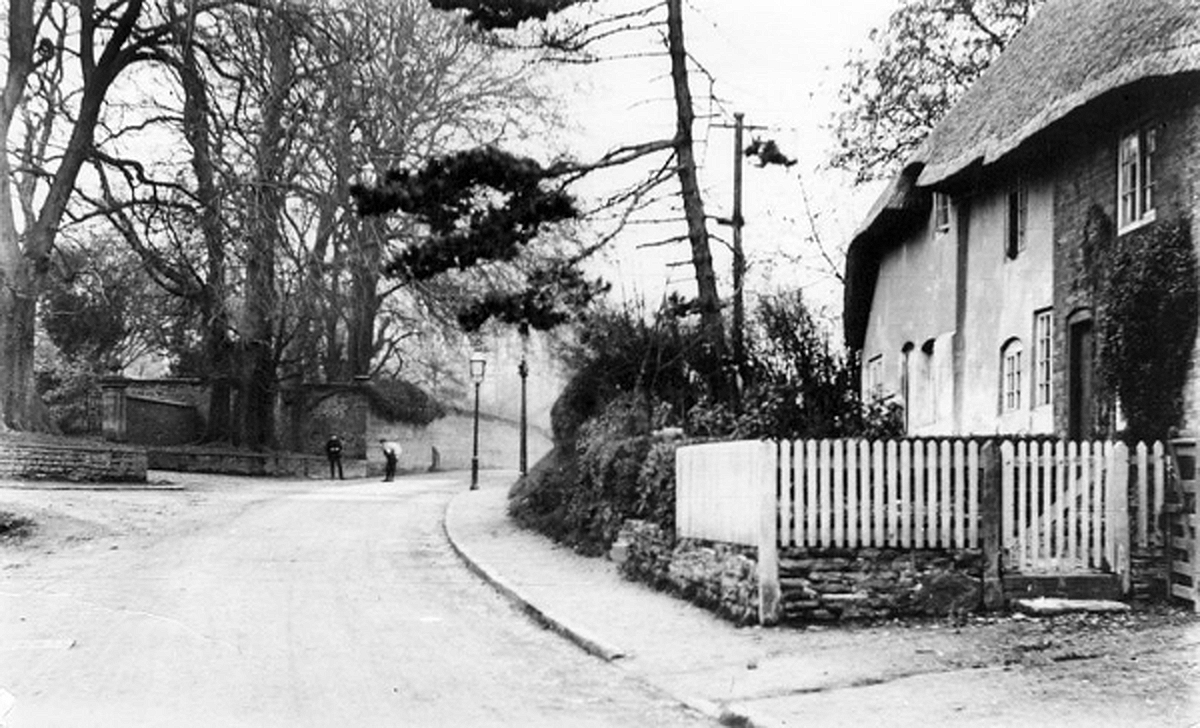
Like any other road, it has been dug up by utility companies numerous times so it is hard to imagine that the Roman section could have been missed. But it does remain a possibility if those services and the road did not coincide. The main road through Watnall has also been widened since 1929 and resurfaced many times. Hopefully its depth would preserve it from roadworks. The old cottages on the right of the road have been demolished and the old perimeter wall of Watnall Hall moved back to accommodate the widened road. The old yew tree mentioned by Mr. Hobbs was opposite The Hollies according to Paul Redgate but is long gone. Probably a victim to the road widening too. However, close inspection of the immediate area shows a young yew tree growing in the grounds of Dairy Barn cottage just opposite and a yew sapling by the Hollies. Legacies of the old tree perhaps?
 |
| Now and then - Watnall Main Road. The Hollies is on the left in both pictures. |
 |
| c.1950 - This is the probable location of the Roman road. By the old yew tree opposite The Hollies |
 |
| What did the Romans ever do for us? Built a road through Watnall maybe? |
Romans in Watnall?
There is one official record of Romans being in Watnall⁴. A Roman brooch or "fibula" was found with a human skeleton buried in a garden on Long Lane in 1895. There is also plenty of evidence of Roman infrastructure in the nearby area.
A significant Roman military fort was found during the building of the Broxtowe housing estate in 1937. It dates from around AD 50-75, quite early in the occupation, and a Roman trackway runs from it via Strelley/Bilborough to a strategically important crossing of the River Trent near Attenborough. The Romans initially used the Trent as a north/south barrier before starting to venture across into hostile territory around AD70.
 |
| Osmanthorpe fort and road |
The Roman forts at Broxtowe, Osmanthorpe and Newton-on-Trent are regularly positioned along the Trent Valley in a manner which is suggestive of a linked route, perhaps to keep a watch on the southern Brigantine border which cut across north Notts and Derbyshire.
A recently discovered Roman road at Bilsthorpe links to Osmanthorpe fort via "Camp Hill" an older Iron Age hill fort. Watnall's "Cliff" would have made an excellent high level vantage point when the Romans began venturing north of the Trent.
Derby was an important Roman settlement with roads radiating out linking to other Roman settlements in Nottinghamshire. The Wirksworth Archaeology Society have discovered and excavated sections of the Roman road called "The Street" which runs north from Derby. However, much of it's original course remains unknown.
 |
| Large and small - short-term Roman "marching" camps have been found nearby |

Marching camps - On campaign, soldiers lived in camps protected by turf ramparts and wooden stakes. These were basic settlements lacking even the most rudimentary sanitation, and during their stay soldiers lived in leather, traditionally goatskin, tents which had to be paid for out of their wages, splitting the cost eight ways with the rest of their squad or "contubernium".
Roman Coal
Or perhaps they were here for the coal? The Roman's were the first recorded coal miners in England. Coal from the East Midlands coalfields was carried along the Car Dyke for use in forges to the north of Duroliponte (Cambridge) and for drying grain from this rich cereal-growing region. Extraction was not limited to open-cast exploitation of outcrops near the surface. Shafts were dug and coal was hewn from horizontal galleries following the coal seams².
 |
| One of the old cottages opposite Watnall Hall demolished when the road was widened. |
 |
| Widening the road opposite the Queens Head by rebuilding Watnall Hall's old wall further back |
 |
| Watnall main road before widening and the Hall's wall on the right |
Turnpike road?
Could the mysterious road be part of the old turnpike road which ran through Watnall? The current B600 was once part of the Nottingham to Newhaven (Derbyshire) turnpike built in 1758. Toll booths were placed along the road at intervals where you had to pay the toll gate keeper to use the road. The Chain Cottages at Watnall corner were so called as the toll gate chain used to hang across the road there. They were owned by the Watnall estate and several employees at the hall have lived there. The coming of the canals and railways did for the toll roads and they eventually fell into increasing disrepair when tolls were abolished.
However, most toll roads were not constructed in the way described by Mr. Hobbs so it is unlikely to be the old turnpike. Also the depth of "a yard" down to the road surface would suggest something older than a couple of hundred years.
 |
| Chain cottages, Watnall - site of the turnpike toll-booth chain |
In 1855 tolls for the Watnall section of the turnpike were as follows...
"For every Horse or Beast of Draught drawing any Coach, Barouche, Berlin, Landau, Chariot, Chaise, Chair, Caravan, Curricle, Calash, Hearse, Litter, Gig, Sledge, or other such Carriage, the Sum of Fourpence Halfpenny:"
with a sliding scale for lower classes of vehicle. It got pretty complicated though...
For every Carriage with Wheels of the Breadth of Six Inches or upwards, laden with any Millstone, Block of Stone, Piece of Timber, Boiler, Pieces of Metal or Machinery, and drawn by Five Horses or other Beasts of Draught, the Sum of Two Shillings and Sixpence, and if drawn by more than Five Horses or other Beasts of Draught, the further Sum of One Shilling for each such Horse or Beast of Draught exceeding that Number; and for every Carriage with Wheels of less Breadth than Six Inches, loaded as aforesaid, and drawn by Five Horses or Beasts of Draught, the Sum of Three Shillings and Ninepence, and if drawn by more than Five Horses or Beasts of Draught, the further Sum of One Shilling for each Horse or Beast of Draught exceeding that Number:
For every Horse, Mule, or other Beast, laden or unladen, and not drawing, the Sum of Three Halfpence:
For every Drove of Oxen, Cows, or Neat Cattle, the Sum of Ten-
pence per Score, and so in proportion for any greater or less Number; and,
For every Drove of Calves, Hogs, Swine, Sheep, or Lambs, the Sum of Fivepence per Score, and so in proportion for any greater or less Number:
For every Goat or other Animal not herein-before provided for, drawing any Carriage, the Sum of Twopence:
For every Carriage propelled by Steam or otherwise than by Ani- mal Power, the Sum of One Shilling for each Wheel.
Sources and notes:
Watnall Hall and the Rolleston Family - RA Horton 2000;
Picture credits - Creative Commons, Carolynn Hobbs and Bill Jackson Collection.
1 - Worcester Roman road - https://www.goodnewsnetwork.org/2000-year-old-roman-road-uncovered-in-british-field-is-like-no-other-and-of-global-importance/
Sterling Roman road - https://www.bbc.co.uk/news/articles/cn0d83q4ng1o
"The Street" Roman road in Derbyshire - excavations https://oldroadsofderbyshire.com/2023/04/07/all-roads-lead-to/
Nottingham Newhaven Toll Act 1855 https://www.legislation.gov.uk/ukla/Vict/18-19/92/pdfs/ukla_18550092_en.pdf
Construction of Roman roads - English Heritage
The structure of Roman roads varied greatly, but a typical form was an agger, or bank, forming the road’s core, built of layers of stone or gravel (depending on what was available locally). In areas of soft ground the road might be built over timber piles and layers of brushwood. The core of the agger would be covered with a layer of larger stones, if available, with the upper surface being formed from layers of smaller stones or gravel.
The full ‘road zone’ could be defined by ditches set some distance from the road, providing drainage and possibly space for pedestrians and animals.
The width of roads varied from about 5 metres to more than 10 metres. Some were far less well constructed than roads of the type described above. Less than half a mile south of the Roman town of Cataractonium (Catterick, North Yorkshire), the main Roman road north to Hadrian’s Wall, Dere Street, consisted of nothing more than successively wider spreads of gravel over a shallow agger.
2 - R. G. Collingwood; Nowell Myres (1936). Roman Britain and the English settlements (1990 ed.). New York: Biblo and Tannen. p. 231. ISBN 9780819611604.
3 - History of roads in the UK http://www.turnpikes.org.uk/Reading%20turnpike%20roads.htm
4 - Roman Nottinghamshire
Watnall - Historic England Research Records - Monument Number 317870 Hob Uid: 317870
Grid Ref : SK5000046000
Summary : A human skeleton and a Roman brooch were found in a garden on the Long Lane road between Watnall at Hucknall.
More information : A Roman fibula and a skeleton in halves, was found at a depth of two feet in a garden on the Long Lane road (SK 5046) between Watnall at Hucknall. (1)
Source details : Page(s) : 197 Vol(s) : 13 - 1895
Broxtowe – north western area of Nottingham where a Roman fort was found in 1937 and then covered over the following year because a new housing estate was being built. Many items of jewellery and other artefacts were found there, but there is no sign of the fort today.
Dorket Head – hill near Arnold, north of Nottingham, where the outline of a Roman fort and a significant collection of Iron Age pottery were found by Sherwood Archaeological Society.
Calverton – small former mining town in mid-Nottinghamshire where two temporary Roman military camps have been seen from the air and two large Roman coin hoards were found in 1959 and 1960.
Hucknall – town northwest of Nottingham where, among other things, a hoard of 24 silver denarii from the reign of Hadrian were recently found.
The Calverton Roman coin hoards - https://archaeologydataservice.ac.uk/archiveDS/archiveDownload?t=arch-5534-1/dissemination/PDFs/1960/TTS_064_1960_04_009-020.pdf
Calverton Roman camps - https://historicengland.org.uk/listing/the-list/list-entry/1018264?section=official-list-entry
Roman Bilborough http://www.stmartinshiddentreasures.org.uk/wp-content/uploads/2017/09/Picture-Bilborough9.1-Final.pdf
Live in the Roman Army in Britain https://the-past.com/feature/legion-tracing-the-impact-and-the-experiences-of-the-roman-army-in-britain/
5 - Electricity at Watnall Hall
In 1937 Colonel Rolleston of Watnall Hall celebrated his 90th birthday. In spite of his great age, he had retained his sense of humour. His chaffeur, Mr. Justice, told Mr. Peart (the last gardener at the hall who started after the Colonel had died in 1941) that about this time mains electricity was installed in the Hall. The Colonel had asked the electrician how long the installation would last. On being told it was good for about 25 years, the Colonel exclaimed, "What! Have I got to go through all this again in twenty-five years time?"
The hall also had a "Generator Room" in one of the outbuildings. All the old electric cables to the hall originated here. It is not known if this was connected to the mains supply (like a transformer) or was a standalone source of electric. In the pic below, taken in 1955, the cables can be seen snaking around the old tithe barn on the way to the hall...

6 - Debunking Roman roads
Lots of bunk and unsubstantiated "facts" have been written about Roman roads. For example this one discovered in 2023 in England was a very convincing "Roman road" until it was analysed and proved to be a natural limestone pavement...

Comments
Post a Comment